
Predictive Slope Failure Analysis
Retrospective Sentinel-1 InSAR Evaluation of an Active Open-Cast Pit Wall Collapse
Executive Summary
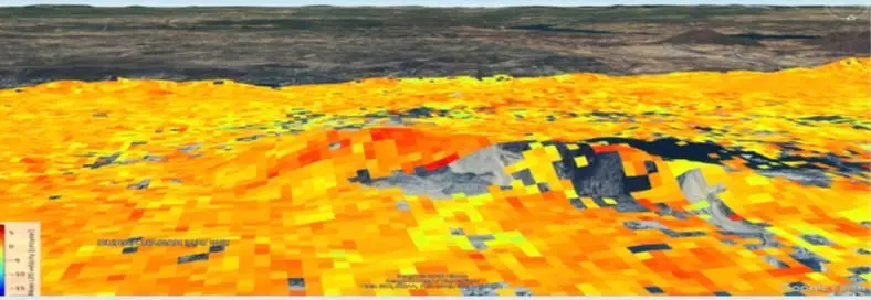
In 2025, a severe quarry wall collapse occurred at an active open-cast mining operation during routine drilling, burying equipment and personnel. InSpectiv Labs performed a retrospective 12-month SBAS InSAR analysis across a 5 sq km footprint leading up to the incident month. The satellite radar data confirmed that the site suffered from widespread, multi-hectare terrain instability, with critical high-velocity failure zones concentrating directly along the upper pit wall crest months prior to the collapse.
The Challenge
Open-cast quarrying continuously alters slope geometry, stress distributions, and bench stability. Slope failures are rarely sudden; they stem from progressive internal stress buildup, bench weakening, and subtle surface displacement over time. Traditional physical inspection and localized survey tools often fail to cover broad, multi-hectare pit faces continuously, leaving slow-developing slope instabilities undetected until structural failure occurs.
InSpectiv Labs Solution & Methodology
Data Engine
Processing Technique
Measurement Physics
Analytical Focus
Key Technical Findings
| Zone Classification | Observed Satellite Signal | Geotechnical Interpretation & Action |
|---|---|---|
| Critical Red Hotspots | High negative LOS velocity / concentrated deep red clusters along pit crest (~50 sq m) | Point of maximum acceleration and slope failure. Serves as a clear, localized early warning indicator directly along the active excavation crest. |
| Widespread Site Instability | Predominant yellow and orange grid patterns across the broader quarry area | Indicates that the majority of the surrounding site was undergoing progressive surface shift and escalating ground stress rather than remaining stable. |
Business Impact
Predictive Lead-Time
Demonstrates that satellite radar can identify subtle slope shifts and broad terrain stress months before physical collapse occurs.
Targeted Geotechnical Intervention
Pinpoints exact high-risk slope sections to prioritize ground checks, instrumentation placement, and bench reinforcements.
Worker & Asset Protection
Provides independent spatial intelligence to adjust excavation schedules and keep workers out of hazardous zones.
Want similar insights for your assets?
Connect with our geotechnical monitoring experts to discuss your requirements.
Contact Us